Monday, June 6, 2011

The Afton Loop--August 18, 2010

The Wyoming Range out of Afton. Rugged, remote, and relentless. More than eight hours on trail, I saw no one, came across no tracks, and pushed through a route that--to my knowledge and the all the locals I know--had never been attempted on a mountain bike. What else could a solo backcountry mountain biker ask for? There were times I thought I'd bitten off more than I could chew, but perserverance paid off in the end.


I've spent quite a bit of time in Afton, Wyoming for work and last year I took my bike up to ride after work. One of the guys that I work with who lives there showed me a couple of trails right out of town, but after I got to looking at the map, I realized I could potentially make a good loop in the Wyoming Range on very lightly used trails.


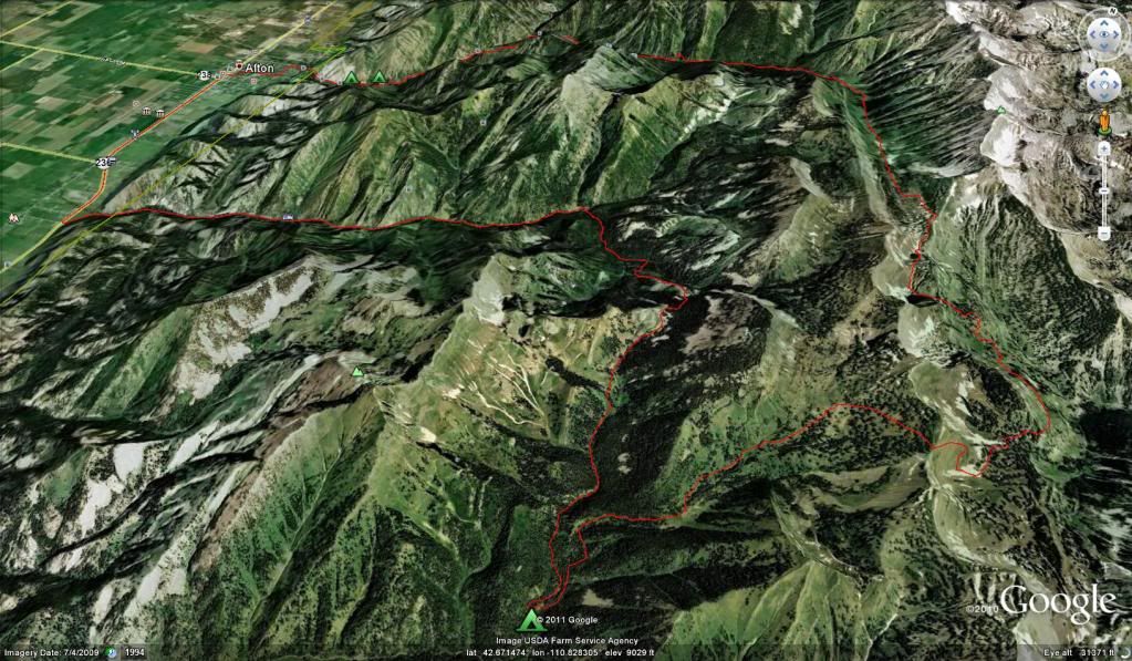
I started in Afton early in the morning. The temp was just at freezing. The first part of the ride was up a well used gravel road to the Periodic Springs on Swift Creek.


The next part was where the singletrack leaves the gravel road. This singletrack is not for those who doubt their skills. Although the trail was not overly difficult, a fall to the downhill side could've easily spelled disaster on this solo adventure.


After the first section of Swift Creek trail, the trail turns and continues to climb up from the valley to the crest of the Wyoming Range.

Once on the crest (after quite a bit of hike-a-bike), there appeared to be a new trail that didn't follow what I had planned for based on the USGS Quads. I figured I'd take the new trail since it appeared to go in the direction that I wanted to go without dropping as far into the valley as I had originally planned for. Once I dropped over the backside, I knew I was relatively committed to completing the loop, as it would be a long, long, slog if I couldn't get back over the crest. I'm glad I decided to go that route. It went directly by a couple of lakes in the leeward side of the ridge with beautiful views.


The next section was the start of the climb back to the crest. After the initial hike-a-bike, there was some great sections of singletrack. Then there was the long carry-a-bike to get to the top of the slope the locals call 'Balls'. I guess it gets its name because it takes big ones to drop this leeward slope on a snowmobile. More than one snowmobiler has been killed in avalanches here.


Once over the crest, I could've just dropped down the ATV trail to the gravel road on Cottonwood Canyon and got back out to the pavement, but what fun would that be, I decided to take the road way less traveled and hop over the ridge to extend the adventure. It started out great, nice trail, somewhat rideable...Then the trail disappeared all together leaving me hunting for even a reminant of an animal trail to make riding (instead of pushing/carrying) even an option.


I started cramping on the climb which didn't make it any easier to get over the top. But once I did find the top, I needed to try and find the trail. When I did find the trail, it was steep and loose. I chased a moose, and then it was back down the dirt road to town.

Here's the stats:
35.52 miles
7500 ft of climbing
7:43:36 moving time
8:24:39 total time

Friday, May 13, 2011

An update

Well, these updates are turning into almost annual updates...I promise to do better in the future...I might take a step back and blog on some of these 2010 events in more detail in the future. For now, here's a recap:


Let's see...I spent a lot of time hiking around Idaho collecting water samples for work.


Went to Teton Pass to do some riding...A little too early for the first trip but nailed it on the second trip...


Got a chance to do a solo trip outside of Afton, WY in the Wyoming Range. I saw absolutely no one (and no one bothered to tell me that riding with my headphones was illegal). I think it was about 30 miles and some of that had no trail. I was waaaay out of shape to be doing it but it was still fun.


Rode in Green River, WY on my travel day to SE Idaho.


I took my family on vacation to WY, ID, and MT.


Raced the Dakota-Five-O (didn't do so well)


I started taking glider lessons out of Boulder and soloed in October


Took a tow out of Driggs, ID in a glider and stayed up for 2hrs right next to the Grand.


Went skiing with my daughter.


Went skiing with a good friend from Montana.


Built a couple new RC planes, went RC flying with friends, and wrecked a plane.


Sunday, February 28, 2010

What have I been up to?

Well...Not enough of this:

The Annual Jackson Hole Backcountry Trip -- Feb 2010 from Jim Jonas on Vimeo.


No really, mostly work, flying my planes, and skiing/riding at Loveland with my daughter.

Saturday, August 1, 2009

Argentine->Lenawee->Loveland Loop

The Argentine->Lenawee->Loveland loop is a ride that I've done the last three years. The last two years, I did it solo and about a month earlier. This year, I was fortunate to have a good friend send me an email on Thursday asking if I was up for a ride. So I told him my plans and he and a friend were interested in joining. They didn't think they'd have the time to complete the whole loop so we met in Keystone at 6:30am, dropped a couple of cars, and made the shuttle back over to Georgetown. We were on the bikes by 7:30am and headed up the first climb (Bike path to Pavillion Point).

I was shocked on the drive up to see so much snow on Bard Peak, Torrey's and even a little on Lenawee Ridge. I was glad I threw my winter hat and a pair of long underwear in my pack before I left.

Within a couple of hours, we were within sight of the top of the climb (Argentine Pass)

Argentine Pass

With lots of snow in sight too.
Argentine Gulch

After the Waldorf mine (~12,000ft), the real work began. It had been a railroad grade up to this point, but beyond was granny gear and walking to reach the pass. I kept thinking on the way up that we would top out around 13,100ft, but my GPS told me I was off by about 400ft...The pass is at 13,500ft...When we reached the top, it was time to put on all the clothes in the pack to manage the cold and the wind. Just as I started down the pass, my rainpants get caught on the seat and I rip the butt out of them...The rip just got worse and worse on the descent.

Dave pointing at Lenawee ridge

For one of the guys, it was his first time riding at this altitude. I think that the mixture of the altitude, cold, and exposure of the trail was a bit intimidating for him. He took two good tumbles off the downhill side of the trail onto the scree (OUCH!!!) Here's a shot of where he fell off the first time.

Don's tumble spot

He ended up banging up his knee and wrist pretty good. But continued to push through his fears and remount his bike to ride through the loose talus that composed the trail.

Argentine Pass

Anyone who's ridden Argentine Pass into Peru Gulch will remember the 'step' about half way down. In the previous two years, I've had to traverse steep snow fields at the step which really increased the difficulty of this loop. Traversing the snowfields was considerably more difficult that the cornice on Jones because you're always off balance when you move the bike or have to kick in steps to the side instead of straight up. Moving this ride to early August made it much more enjoyable.

The Step
Argentine Pass

A short video of Argentine Pass:


When we reached the base of Lenawee, I was able to convince DK to continue up and over to A-basin with me while DD parted ways and headed down the road to Keystone. We didn't get but a few feet up Lenawee when DK's cassette came loose. Of course, we didn't have a cassette tool so we had to try to tighten it as best we could with my leatherman. It ended up holding the rest of the ride. I didn't get many shots of Lenawee because DK was kicking my butt on the climb and every time I was able to get the camera out he was out of view.

Lenawee trail climb

Lenawee Trail

It only took us 2:10 to reach A-basin from the Peru Gulch Rd(including the mechanical issue) and we bombed down the service road to Loveland Pass.

A view of the last climb of the day from the top of the second.
Top of A-basin

I almost had DK convinced to finish off the loop with me...But it was down to just me climbing up and over Loveland Pass. I made a quick stop at the top to get on more clothes (again) and then it was coasting and cruising down Loveland Pass, BLT, the frontage road, and finally the bike path back to the car.

It took a little over 9hrs this year.

More Pictures here